What Galveston's New Wayfinding Signs Are Built to Keep Off Your Street
October 8, 2026
October 8, 2026
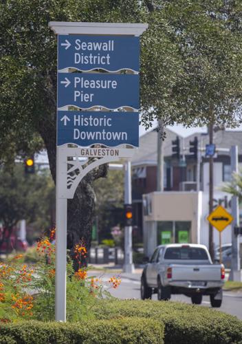
The new blue-and-sand signs going up around Galveston are meant to keep visitor traffic on four roads. They send drivers along Broadway, Harborside Drive, Seawall Boulevard and FM 3005 and the main streets that connect them. Visit Galveston says the goal is to cut down on visitors driving through residential neighborhoods. Once you know that, a lot of the details make sense. That includes the district names, the places that never got a sign, and the Seawall sidewalk placements people have been complaining about.
The system costs $1.5 million and includes about 400 signs at 214 locations. In an interview with The Daily News published around October 1, 2026, Visit Galveston's Caitlin Carnes said installation was on track to finish by the end of the month. Hotel occupancy tax paid by overnight visitors covers the cost. Property taxes don't, and state law lists signs that direct visitors to attractions as an allowed use of that tax. Visit Galveston calls it the first islandwide signage system in Galveston's history.
The system guides people in stages. When a driver comes onto the island, the first signs point toward a district. Inside the district, signs lead to major destinations and public parking. After the car is parked, smaller pedestrian signs and map kiosks take over. The kiosks show walking times, so visitors can tell what's a short walk and what's worth a trolley ride. The brown nameplate at the top of each sign tells you which district you're in.
District | What the signs group inside it |
|---|---|
Port District | Cruise terminals, Pier 21, Pelican Island and Seawolf Park |
Historic Downtown | The Strand, museums, shopping and dining |
Seawall District | Miles of beach, the Pleasure Pier, hotels and restaurants |
East End | East Beach, the East End Lagoon Nature Preserve and the historic East End neighborhood |
West End | Galveston Island State Park, beach parks and quieter stretches of coast |
None of these districts is official in any legal sense. Visit Galveston says they aren't city limits, zoning districts or neighborhoods, and that "they don't change anything about where you live or own property." The names came from how people already talk about the island. Most people already call that stretch of Seawall Boulevard "the Seawall," and East End and West End were common names long before the signs. The names were kept broad on purpose, so a district can grow without being renamed. A few major attractions, such as Moody Gardens, sit outside any district and get signs with their own names.
A driver has only a few seconds to read a sign, so each panel fits just a few names. To decide which places make the cut, the program starts with Texas Department of Transportation guidelines. Those look at whether a place is open to the public, open year-round, has public parking and draws a large number of visitors. Places that meet the most criteria show up on signs across the island. Others appear only near where they are, on pedestrian signs or on the kiosk maps. Visit Galveston says a sign pointing to Historic Downtown or the Seawall points to every shop and restaurant there.
Hospitals are left off on purpose. TxDOT's blue H signs already direct drivers to the nearest emergency room, and the new signs stay out of their way.
Downtown is the one part of the island getting new street signs as well. Everywhere else, the existing city street signs stay as they are. The new downtown signs look a little odd at first. Here's how to read them:
The same routing plan explains why the Seawall got so many signs and why that's where most of the complaints are. If visitor traffic is supposed to stay on Seawall Boulevard, that's where the directions have to be, and the Seawall sidewalk is already crowded.
The Daily News reported that residents complained most about placements along the seawall. The new signs went up next to drop-off warning signs, parking signs, decorative oil derricks and restrooms. Seawall users were already worried about a growing mix of walkers, cyclists, surrey riders and people on fast-moving e-bikes and scooters. Leslie LeCornu, co-owner of The Admiralty at 2221 Strand, told the paper, "I wish they would've put them on the other side of the street, not blocking the bikes and the pedestrians."
One resident raised accessibility as a main concern, taking a tape measure to the seawall. The signs the resident checked appeared to meet ADA clearance requirements, but the resident told the paper there were still doubts about how the project was carried out. Corbin Design, the Michigan firm that planned the system, said it considered existing conditions and accessibility requirements when choosing exact spots. It also had to coordinate with every agency that controls the public right of way, including the city, the county, TxDOT and the U.S. Army Corps of Engineers. A sign can only go where all of those agencies allow it, which may explain some of the placements that look strange from the sidewalk.
Past the end of the seawall, there are fewer signs and the destinations are simpler. Visit Galveston's description of the West End District names Galveston Island State Park, beach parks and quieter stretches of coast. The sign-message schedule in the Park Board's fabrication bid lists West End signs on FM 3005 for Dellanera RV Park and public beach access 5. It also lists signs for Pocket Parks 1 and 2 and beach accesses 6 through 9, including a location on San Luis Pass Road. That list came from the bidding stage, so some final placements may differ.
For anyone living on the West End, this means the signs mostly point visitors toward public beach access and parking. Visit Galveston's materials describe a West End wayfinding area along FM 3005. Nothing we found names individual West End subdivisions or Jamaica Beach as sign destinations.
Corbin Design based the look on details from around the island. The cornice across the top echoes the buildings of Historic Downtown, and the bracket underneath comes from the porches on Galveston homes. The district nameplate is shaped like the nameboard on a historic ship, and a wave edge runs along the bottom of each panel. The main colors are Gulf Blue, Wet Sand and Coastal White. The backs use Sand, Island Blue and Coral, taken from the painted storefronts downtown and the beach houses along the coast.
Walk around to the back of some signs and you'll find Gulf wildlife cut into the panels, including sea turtles, dolphins, pelicans and sheepshead. Visit Galveston invites people to see how many they can spot.
Each map kiosk also carries a panel on one of six Galveston history topics. The panels rotate among kiosks around the island, so the one near Pier 21 may tell a different story than the one on the Seawall:
The signs are made of aluminum with a marine-grade finish and are designed to last 10 years or more. They're built in sections, so a damaged panel can be repaired and destination names can change as the island does, without replacing the whole sign. When a restaurant closes or a new attraction opens, the fix is a new panel.
Those replaceable panels also make the next few months a good time to speak up. Carnes told The Daily News that contractors were still working through their punch list and the project hadn't reached final inspection. She said corrections and changes don't cost the island anything, because Corbin Design and Geograph Industries, the Ohio company that built and installed the signs, carry that cost. The early misspellings were fixed within 48 hours.
If you've seen old and new signs standing side by side, that should end soon. Visit Galveston says removing the old wayfinding signs is part of the final installation phase, and it acknowledges that the overlap has caused some temporary clutter and confusion.
Visit Galveston handles reports in two ways. Clear errors that send people the wrong way get fixed promptly. Other comments and preferences are logged and reviewed together later, after about four to six months of normal use, which is how long the consultants recommend waiting so first reactions can be separated from lasting problems. A placement complaint sent this fall will be on file when that review happens. To report a sign, email [email protected] with the location, a photo if you can and a short note.
If you have bigger questions about how visitors and residents share the island, the City of Galveston is holding its second Comprehensive Plan community workshop on Thursday, October 15, from 3 to 7 p.m. It's at the Historic Galveston Water & Electric Light Community Center, 715 30th Street. The plan will guide decisions on transportation, infrastructure and future land use. At the first workshop, participants named protecting Galveston's natural resources as the most important goal, and balancing the needs of residents and visitors was among the second-tier priorities.
Shani Atkinson has spent years watching how Galveston's main roads, side streets and beach accesses work, from the Seawall all the way out FM 3005. If you'd like to talk about how traffic and visitors reach a particular part of the island, get in touch and we can look at it together.
This article is general information, not legal, tax or financial advice. Consult a qualified professional about your situation.
Stay up to date on the latest real estate trends.
With deep island knowledge and a client-first mindset, Shani helps you navigate the Galveston market with confidence—delivering clarity, communication, and exceptional outcomes.